


chagey

jacthiry
User
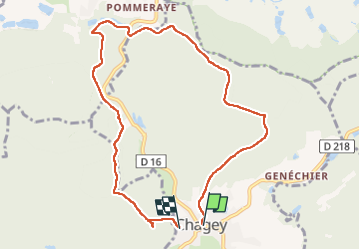

Length
8.9 km

Max alt
451 m

Uphill gradient
230 m
Km-Effort
11.9 km

Min alt
346 m

Downhill gradient
226 m
Boucle
No
Creation date :
2023-01-26 12:49:03.707
Updated on :
2023-01-26 15:32:27.249
2h42
Difficulty : Medium

FREE GPS app for hiking
 SityTrail
IGN / Geographical institutes
SityTrail Plus
The world is yours!
About
Trail Walking of 8.9 km to be discovered at Bourgogne-Franche-Comté, Haute-Saône, Chagey. This trail is proposed by jacthiry.
Positioning
Country:
France
Region :
Bourgogne-Franche-Comté
Department/Province :
Haute-Saône
Municipality :
Chagey
Location:
Unknown
Start:(Dec)
Start:(UTM)
329625 ; 5275703 (32T) N.
Comments