


Marchampt (15 km - D. 650 m)

Thomasdanielle
User
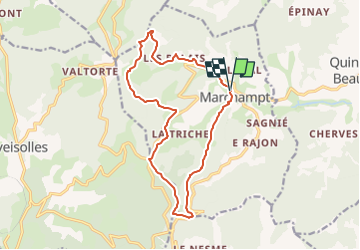

Length
14.9 km

Max alt
789 m

Uphill gradient
649 m
Km-Effort
24 km

Min alt
366 m

Downhill gradient
652 m
Boucle
Yes
Creation date :
2023-01-27 11:18:24.533
Updated on :
2023-01-27 16:16:23.63
5h20
Difficulty : Very difficult

FREE GPS app for hiking
 SityTrail
IGN / Geographical institutes
SityTrail Plus
The world is yours!
About
Trail Walking of 14.9 km to be discovered at Auvergne-Rhône-Alpes, Rhône, Marchampt. This trail is proposed by Thomasdanielle.
Description
Parking : Voir avec Jean
Tables pour le pique-nique se trouvent après 8,5 km
Positioning
Country:
France
Region :
Auvergne-Rhône-Alpes
Department/Province :
Rhône
Municipality :
Marchampt
Location:
Unknown
Start:(Dec)
Start:(UTM)
621306 ; 5107879 (31T) N.
Comments