


st victoire refuge cezanne chapelle du Trou

ego
User
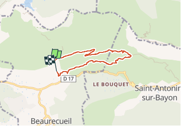

Length
6.5 km

Max alt
455 m

Uphill gradient
200 m
Km-Effort
9.2 km

Min alt
258 m

Downhill gradient
212 m
Boucle
No
Creation date :
2023-01-27 10:06:10.669
Updated on :
2023-01-27 14:23:25.164
2h18
Difficulty : Medium

FREE GPS app for hiking
 SityTrail
IGN / Geographical institutes
SityTrail Plus
The world is yours!
About
Trail Walking of 6.5 km to be discovered at Provence-Alpes-Côte d'Azur, Bouches-du-Rhône, Beaurecueil. This trail is proposed by ego .
Positioning
Country:
France
Region :
Provence-Alpes-Côte d'Azur
Department/Province :
Bouches-du-Rhône
Municipality :
Beaurecueil
Location:
Unknown
Start:(Dec)
Start:(UTM)
705667 ; 4822313 (31T) N.
Comments