


Plat de la Peyre

chasle
User
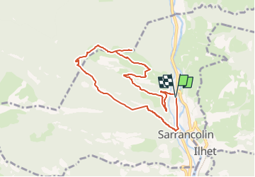

Length
8.7 km

Max alt
1153 m

Uphill gradient
630 m
Km-Effort
17.1 km

Min alt
619 m

Downhill gradient
630 m
Boucle
Yes
Creation date :
2023-01-28 16:44:58.165
Updated on :
2023-01-28 16:48:05.235
0m
Difficulty : Medium

FREE GPS app for hiking
 SityTrail
IGN / Geographical institutes
SityTrail Plus
The world is yours!
About
Trail Snowshoes of 8.7 km to be discovered at Occitania, Hautespyrenees, Sarrancolin. This trail is proposed by chasle.
Positioning
Country:
France
Region :
Occitania
Department/Province :
Hautespyrenees
Municipality :
Sarrancolin
Location:
Unknown
Start:(Dec)
Start:(UTM)
285998 ; 4761190 (31T) N.
Comments