


Col de la Perheux

Claudele
User

Length
13.1 km

Max alt
706 m

Uphill gradient
396 m
Km-Effort
18.4 km

Min alt
345 m

Downhill gradient
396 m
Boucle
Yes
Creation date :
2014-12-10 00:00:00.0
Updated on :
2014-12-10 00:00:00.0
3h58
Difficulty : Easy

FREE GPS app for hiking
 SityTrail
IGN / Geographical institutes
SityTrail Plus
The world is yours!
About
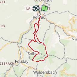
Trail Walking of 13.1 km to be discovered at Grand Est, Bas-Rhin, Rothau. This trail is proposed by Claudele.
Positioning
Country:
France
Region :
Grand Est
Department/Province :
Bas-Rhin
Municipality :
Rothau
Location:
Unknown
Start:(Dec)
Start:(UTM)
367520 ; 5368611 (32U) N.
Comments