


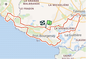
Talmont Cayola

taguette
User

Length
27 km

Max alt
30 m

Uphill gradient
252 m
Km-Effort
30 km

Min alt
0 m

Downhill gradient
251 m
Boucle
Yes
Creation date :
2023-01-29 07:09:54.981
Updated on :
2023-01-29 12:00:55.622
4h30
Difficulty : Medium

FREE GPS app for hiking
 SityTrail
IGN / Geographical institutes
SityTrail Plus
The world is yours!
About
Trail Walking of 27 km to be discovered at Pays de la Loire, Vendée, Talmont-Saint-Hilaire. This trail is proposed by taguette.
Positioning
Country:
France
Region :
Pays de la Loire
Department/Province :
Vendée
Municipality :
Talmont-Saint-Hilaire
Location:
Unknown
Start:(Dec)
Start:(UTM)
602355 ; 5145093 (30T) N.
Comments