


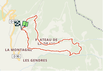
Boucle de la Draye champ Éric et Valentine

damlou
User


1h54
Difficulty : Medium

FREE GPS app for hiking
 SityTrail
IGN / Geographical institutes
SityTrail Plus
The world is yours!
About
Trail Snowshoes of 5.2 km to be discovered at Provence-Alpes-Côte d'Azur, Hautes-Alpes, Crots. This trail is proposed by damlou.
Description
Montée vers clos Besson
partir sur la gauche dans forêt chemin parallèle au chemin tracé
Arrivée cailloux
Basculer à droite direction Morgon
Suivre champs contourner vers la gauche puis aller vers canal vers la droite direction à droite aiguille charnières
Descendre vers gite
Positioning
Comments