


Pannessières courte

drarep
User
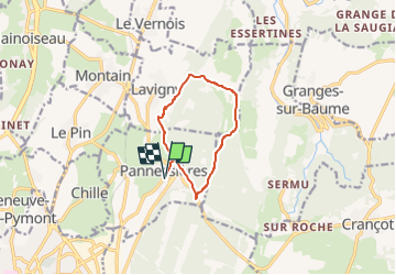

Length
8.9 km

Max alt
516 m

Uphill gradient
247 m
Km-Effort
12.2 km

Min alt
339 m

Downhill gradient
246 m
Boucle
Yes
Creation date :
2023-01-08 12:13:29.673
Updated on :
2023-01-29 17:07:46.855
8h35
Difficulty : Medium

FREE GPS app for hiking
 SityTrail
IGN / Geographical institutes
SityTrail Plus
The world is yours!
About
Trail Walking of 8.9 km to be discovered at Bourgogne-Franche-Comté, Jura, Pannessières. This trail is proposed by drarep.
Positioning
Country:
France
Region :
Bourgogne-Franche-Comté
Department/Province :
Jura
Municipality :
Pannessières
Location:
Unknown
Start:(Dec)
Start:(UTM)
698672 ; 5174850 (31T) N.
Comments