Trail Walking Beauchastel - Beauchastel la Grange Roustan - Photo

Beauchastel la Grange Roustan

© OpenStreetMap contributors
Length
Length
12.4 km
Max alt
Max alt
548 m
Uphill gradient
Uphill gradient
479 m
Km-Effort
Km-Effort  
18.8 km
Min alt
Min alt
97 m
Downhill gradient
Downhill gradient
479 m
Boucle
Boucle
Yes
Creation date :
2023-01-29 12:24:41.723
Updated on :
2023-01-29 17:42:05.561

(0 Reviews)

Walking
Walking
3h22
Difficulty : Easy

Scan this QR Code to open this trail in the SityTrail application

FREE GPS app for hiking

Logo SityTrail SityTrail

IGN / Geographical institutes

Download SityTrail from the App Store Download SityTrail from Google Play

Logo SityTrail SityTrail Plus

The world is yours!

Download SityTrail from the App Store Download SityTrail from Google Play Download SityTrail on Huawei AppGallery

About

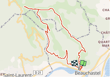
Trail Walking of 12.4 km to be discovered at Auvergne-Rhône-Alpes, Ardèche, Beauchastel. This trail is proposed by TOULAUDIN.

Description

trace parcours réalisé le 29/1/23 beau parcours avec vue sur
vallée du Rhône et de l'Eyrieux .hésitation au départ dans le village suivre la trace .sur le  parcours une partie petite route après la montée du départ .point de vue à la cote 548.pour le retour Attention au KM 7 prendre la descente sur la droite ( il y a un Kern) à la cote 249 on retrouve un beau chemin large ombragé et facile

Elevation profile

Positioning

Country:
France
Region :
Auvergne-Rhône-Alpes
Department/Province :
Ardèche
Municipality :
Beauchastel
Location:
Unknown
Start:(UTM)
641930 ; 4965217 (31T) N.


Close
My subscriptions