


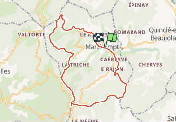
Marchampt (19 km - D. 750 m)

Thomasdanielle
User

Length
18.6 km

Max alt
789 m

Uphill gradient
752 m
Km-Effort
29 km

Min alt
347 m

Downhill gradient
752 m
Boucle
Yes
Creation date :
2023-01-30 08:22:38.0
Updated on :
2023-01-31 10:49:10.257
5h12
Difficulty : Difficult

FREE GPS app for hiking
 SityTrail
IGN / Geographical institutes
SityTrail Plus
The world is yours!
About
Trail Walking of 18.6 km to be discovered at Auvergne-Rhône-Alpes, Rhône, Marchampt. This trail is proposed by Thomasdanielle.
Description
D/A : Parking du moulin
Possibilité de pique-niquer au Col de la Croix Marchampt Alt. 687m sous un abri, bien protégé du vent et de la pluie avec une grande table et des bancs.
Positioning
Country:
France
Region :
Auvergne-Rhône-Alpes
Department/Province :
Rhône
Municipality :
Marchampt
Location:
Unknown
Start:(Dec)
Start:(UTM)
621591 ; 5107626 (31T) N.
Comments