


Angers avec Pierre

bubuserge
User
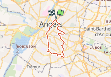

Length
11.4 km

Max alt
53 m

Uphill gradient
100 m
Km-Effort
12.8 km

Min alt
22 m

Downhill gradient
100 m
Boucle
Yes
Creation date :
2023-01-31 07:57:04.0
Updated on :
2023-01-31 11:06:40.233
2h30
Difficulty : Difficult

FREE GPS app for hiking
 SityTrail
IGN / Geographical institutes
SityTrail Plus
The world is yours!
About
Trail Walking of 11.4 km to be discovered at Pays de la Loire, Maine-et-Loire, Angers. This trail is proposed by bubuserge.
Positioning
Country:
France
Region :
Pays de la Loire
Department/Province :
Maine-et-Loire
Municipality :
Angers
Location:
Unknown
Start:(Dec)
Start:(UTM)
684909 ; 5261127 (30T) N.
Comments