


Lac de Meault

aljac
User
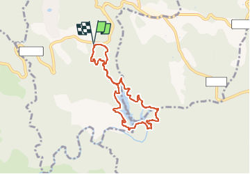

Length
7.5 km

Max alt
269 m

Uphill gradient
165 m
Km-Effort
9.7 km

Min alt
185 m

Downhill gradient
165 m
Boucle
Yes
Creation date :
2023-01-31 13:15:41.169
Updated on :
2023-02-01 04:33:55.445
1h51
Difficulty : Easy

FREE GPS app for hiking
 SityTrail
IGN / Geographical institutes
SityTrail Plus
The world is yours!
About
Trail Walking of 7.5 km to be discovered at Provence-Alpes-Côte d'Azur, Var, Seillans. This trail is proposed by aljac.
Description
Attention passage dangereux le long du déversoir. Suivre le marquage jaune.
Photos

Positioning
Country:
France
Region :
Provence-Alpes-Côte d'Azur
Department/Province :
Var
Municipality :
Seillans
Location:
Unknown
Start:(Dec)
Start:(UTM)
308787 ; 4827967 (32T) N.
Comments