


2023 02 01 monop rer

hal2012
User

Length
3.4 km

Max alt
65 m

Uphill gradient
63 m
Km-Effort
4.2 km

Min alt
37 m

Downhill gradient
55 m
Boucle
Yes
Creation date :
2023-02-01 11:50:39.278
Updated on :
2023-02-01 12:48:58.69
54m
Difficulty : Easy

FREE GPS app for hiking
 SityTrail
IGN / Geographical institutes
SityTrail Plus
The world is yours!
About
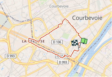
Trail Walking of 3.4 km to be discovered at Ile-de-France, Hauts-de-Seine, Courbevoie. This trail is proposed by hal2012.
Positioning
Country:
France
Region :
Ile-de-France
Department/Province :
Hauts-de-Seine
Municipality :
Courbevoie
Location:
Unknown
Start:(Dec)
Start:(UTM)
445321 ; 5415473 (31U) N.
Comments