Monistrol Aurec par les sauvages

psesjs
User
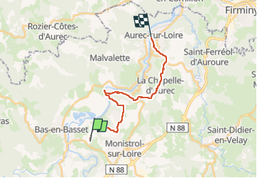

Length
19.1 km

Max alt
678 m

Uphill gradient
485 m
Km-Effort
26 km

Min alt
433 m

Downhill gradient
507 m
Boucle
No
Creation date :
2023-02-01 09:08:25.726
Updated on :
2023-02-01 15:34:55.433
4h49
Difficulty : Easy

FREE GPS app for hiking
 SityTrail
IGN / Geographical institutes
SityTrail Plus
The world is yours!
About
Trail Walking of 19.1 km to be discovered at Auvergne-Rhône-Alpes, Haute-Loire, Bas-en-Basset. This trail is proposed by psesjs.
Positioning
Country:
France
Region :
Auvergne-Rhône-Alpes
Department/Province :
Haute-Loire
Municipality :
Bas-en-Basset
Location:
Unknown
Start:(Dec)
Start:(UTM)
589364 ; 5016647 (31T) N.
Comments