


san peire ste maxime

vincente204
User
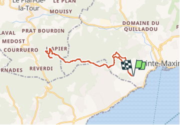

Length
16.9 km

Max alt
401 m

Uphill gradient
590 m
Km-Effort
25 km

Min alt
37 m

Downhill gradient
587 m
Boucle
Yes
Creation date :
2023-02-01 08:41:53.78
Updated on :
2023-02-01 15:54:23.17
7h11
Difficulty : Very difficult

FREE GPS app for hiking
 SityTrail
IGN / Geographical institutes
SityTrail Plus
The world is yours!
About
Trail Walking of 16.9 km to be discovered at Provence-Alpes-Côte d'Azur, Var, Sainte-Maxime. This trail is proposed by vincente204.
Description
difficile
Positioning
Country:
France
Region :
Provence-Alpes-Côte d'Azur
Department/Province :
Var
Municipality :
Sainte-Maxime
Location:
Unknown
Start:(Dec)
Start:(UTM)
306762 ; 4797116 (32T) N.
Comments