


20230202 interm

Jeanclaudebic
User
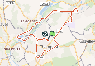

Length
11.2 km

Max alt
157 m

Uphill gradient
88 m
Km-Effort
12.4 km

Min alt
117 m

Downhill gradient
89 m
Boucle
Yes
Creation date :
2023-02-02 07:58:25.113
Updated on :
2023-02-02 10:02:09.967
2h03
Difficulty : Difficult

FREE GPS app for hiking
 SityTrail
IGN / Geographical institutes
SityTrail Plus
The world is yours!
About
Trail Walking of 11.2 km to be discovered at Centre-Loire Valley, Eure-et-Loir, Champhol. This trail is proposed by Jeanclaudebic.
Positioning
Country:
France
Region :
Centre-Loire Valley
Department/Province :
Eure-et-Loir
Municipality :
Champhol
Location:
Unknown
Start:(Dec)
Start:(UTM)
389746 ; 5369798 (31U) N.
Comments