


StRemy les C.

Nourrain
User
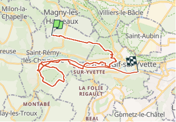

Length
20 km

Max alt
173 m

Uphill gradient
229 m
Km-Effort
24 km

Min alt
63 m

Downhill gradient
315 m
Boucle
No
Creation date :
2023-01-12 09:06:18.0
Updated on :
2023-02-02 13:04:41.715
6h32
Difficulty : Very easy

FREE GPS app for hiking
 SityTrail
IGN / Geographical institutes
SityTrail Plus
The world is yours!
About
Trail Walking of 20 km to be discovered at Ile-de-France, Yvelines, Saint-Rémy-lès-Chevreuse. This trail is proposed by Nourrain.
Description
Randonnée Cara
Positioning
Country:
France
Region :
Ile-de-France
Department/Province :
Yvelines
Municipality :
Saint-Rémy-lès-Chevreuse
Location:
Unknown
Start:(Dec)
Start:(UTM)
432082 ; 5396219 (31U) N.
Comments