


molondin

ludovicpeguiron
User

Length
8.5 km

Max alt
682 m

Uphill gradient
168 m
Km-Effort
10.7 km

Min alt
591 m

Downhill gradient
163 m
Boucle
Yes
Creation date :
2014-12-10 00:00:00.0
Updated on :
2014-12-10 00:00:00.0
--
Difficulty : Unknown

FREE GPS app for hiking
 SityTrail
IGN / Geographical institutes
SityTrail Plus
The world is yours!
About
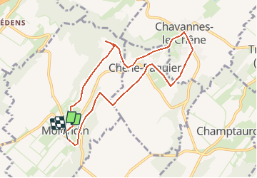
Trail Other activity of 8.5 km to be discovered at Vaud, District du Jura-Nord vaudois, Molondin. This trail is proposed by ludovicpeguiron.
Positioning
Country:
Switzerland
Region :
Vaud
Department/Province :
District du Jura-Nord vaudois
Municipality :
Molondin
Location:
Unknown
Start:(Dec)
Start:(UTM)
328095 ; 5180966 (32T) N.
Comments