


Col de la Rousse

orsel
User GUIDE
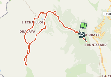

Length
11.2 km

Max alt
2508 m

Uphill gradient
767 m
Km-Effort
21 km

Min alt
1804 m

Downhill gradient
788 m
Boucle
No
Creation date :
2023-02-02 09:43:52.074
Updated on :
2023-02-03 08:38:07.984
3h23
Difficulty : Easy

FREE GPS app for hiking
 SityTrail
IGN / Geographical institutes
SityTrail Plus
The world is yours!
About
Trail Touring skiing of 11.2 km to be discovered at Provence-Alpes-Côte d'Azur, Hautes-Alpes, Arvieux. This trail is proposed by orsel.
Positioning
Country:
France
Region :
Provence-Alpes-Côte d'Azur
Department/Province :
Hautes-Alpes
Municipality :
Arvieux
Location:
Unknown
Start:(Dec)
Start:(UTM)
319710 ; 4963084 (32T) N.
Comments