Trail Walking Saint-Agnan-en-Vercors - Montagne de Neve - Photo
 Greg813
Greg813

User

© OpenStreetMap contributors
Length
Length
9.6 km
Max alt
Max alt
1421 m
Uphill gradient
Uphill gradient
327 m
Km-Effort
Km-Effort  
14 km
Min alt
Min alt
1132 m
Downhill gradient
Downhill gradient
334 m
Boucle
Boucle
Yes
Creation date :
2023-02-03 08:35:52.878
Updated on :
2023-02-25 09:53:28.123

(0 Reviews)

Walking
Walking
2h29
Difficulty : Medium

Scan this QR Code to open this trail in the SityTrail application

FREE GPS app for hiking

Logo SityTrail SityTrail

IGN / Geographical institutes

Download SityTrail from the App Store Download SityTrail from Google Play

Logo SityTrail SityTrail Plus

The world is yours!

Download SityTrail from the App Store Download SityTrail from Google Play Download SityTrail on Huawei AppGallery

About

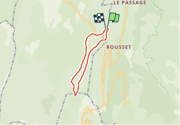
Trail Walking of 9.6 km to be discovered at Auvergne-Rhône-Alpes, Drôme, Saint-Agnan-en-Vercors. This trail is proposed by Greg813.

Description

Randonnée avec Mettons le Monde en Marche, à flan de la montagne de Neve.

Ascension du col de St Alexis et le stade de biathlon jusqu'au col de Chironne.

Réalisé en raquettes en période hivernale.

Pour d'autres photos, voir le site de l'association :
https://mmm-rando.org/decouverte-hivernale-du-vercors-randos-raquettes/

Elevation profile

Positioning

Country:
France
Region :
Auvergne-Rhône-Alpes
Department/Province :
Drôme
Municipality :
Saint-Agnan-en-Vercors
Location:
Unknown
Start:(UTM)
690161 ; 4972226 (31T) N.


Close
My subscriptions