


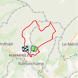
De Ramonchamp à Morbieux

jeanclaude12
User


3h13
Difficulty : Medium

FREE GPS app for hiking
 SityTrail
IGN / Geographical institutes
SityTrail Plus
The world is yours!
About
Trail Walking of 12.5 km to be discovered at Grand Est, Vosges, Ramonchamp. This trail is proposed by jeanclaude12.
Description
Douze kilomètres de randonnée vers le Col de Morbieux en passant par la Montagne des Rochottes, la Broche Joly, les Resses, le Bois des Ponces et retour par le Bois de l'Aireu et son Chalet vers le Col de la Sûre et les Prés Herqué.
Photos


Positioning
Comments