Trail Walking Mathay - 2023-02-06_13h05m30_e5e4d95edab861ad154441d5ac694f2d2aae3641a623cc76f2a104c4890a440 - Photo

2023-02-06_13h05m30_e5e4d95edab861ad154441d5ac694f2d2aae3641a623cc76f2a104c4890a440

 ISATR
ISATR

User

© OpenStreetMap contributors
Length
Length
11.1 km
Max alt
Max alt
565 m
Uphill gradient
Uphill gradient
307 m
Km-Effort
Km-Effort  
15.2 km
Min alt
Min alt
367 m
Downhill gradient
Downhill gradient
305 m
Boucle
Boucle
Yes
Creation date :
2023-02-06 12:05:30.858
Updated on :
2023-02-12 08:09:05.701

(0 Reviews)

Walking
Walking
3h27
Difficulty : Difficult

Scan this QR Code to open this trail in the SityTrail application

FREE GPS app for hiking

Logo SityTrail SityTrail

IGN / Geographical institutes

Download SityTrail from the App Store Download SityTrail from Google Play

Logo SityTrail SityTrail World

The world is yours!

Download SityTrail from the App Store Download SityTrail from Google Play Download SityTrail on Huawei AppGallery

About

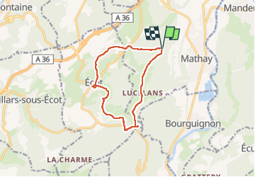
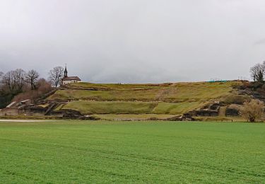
Trail Walking of 11.1 km to be discovered at Bourgogne-Franche-Comté, Doubs, Mathay. This trail is proposed by ISATR.

Description

depart la fourche direction la forêt puis chemin de la memoire
puis Ecot puis monument guerre 40 45 puis retour par la route de LUcelans

Elevation profile

Positioning

Country:
France
Region :
Bourgogne-Franche-Comté
Department/Province :
Doubs
Municipality :
Mathay
Location:
Unknown
Start:(UTM)
331474 ; 5256282 (32T) N.

Trails nearby

Trail Walking Mandeure - Mandeure, Les Grands Communaux 9.6 Km - Photo
Walking
randovoujo

Walking

Difficult
(1)
Mandeure, Bourgogne-Franche-Comté, Doubs, France
9.6 km | 13.2 km-effort
2h 59min
Yes
Trail Walking Bourguignon - Bourguignon, entre eau et forêt 9.5 Km  - Photo
Walking
randovoujo

Walking

Medium
(1)
Bourguignon, Bourgogne-Franche-Comté, Doubs, France
9.5 km | 11.9 km-effort
2h 2min
Yes
Trail Other activity Voujeaucourt - de voujeaucourt à Dambelin, puis pont de roide  - Photo
Other activity
jibus90

Other activity

Very easy
Voujeaucourt, Bourgogne-Franche-Comté, Doubs, France
57 km | 77 km-effort
4h 46min
Yes
Trail Walking Mandeure - source Charles  - Photo
Walking
juliogomez

Walking

Easy
Mandeure, Bourgogne-Franche-Comté, Doubs, France
5 km | 6.4 km-effort
1h 35min
No
Trail Walking Mandeure - Mandeure 1 - Photo
Walking
randovoujo

Walking

Medium
Mandeure, Bourgogne-Franche-Comté, Doubs, France
9 km | 11.9 km-effort
2h 42min
Yes
Trail Walking Mandeure - Etape 1 GTJ : Mandeure à Pont de Roide - Photo
Walking
annefrance70

Walking

Easy
Mandeure, Bourgogne-Franche-Comté, Doubs, France
14 km | 18.1 km-effort
4h 40min
No
Trail Mountain bike Mandeure - Randonnée autour de Mandeure - Photo
Mountain bike
tracegps

Mountain bike

Medium
Mandeure, Bourgogne-Franche-Comté, Doubs, France
25 km | 32 km-effort
2h 0min
No
Trail Cycle Mandeure - Le Lomont - Doubs - Photo
Cycle
tracegps

Cycle

Difficult
Mandeure, Bourgogne-Franche-Comté, Doubs, France
72 km | 89 km-effort
3h 0min
Yes
Trail Walking Mandeure - Mandeure - Doubs - Photo
Walking
tracegps

Walking

Medium
(2)
Mandeure, Bourgogne-Franche-Comté, Doubs, France
9 km | 11.9 km-effort
3h 0min
Yes


Close
My subscriptions