


Plan d'Aups traversée du Paradis -crête Sainte Baume

Jack29
User
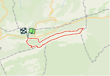

Length
14 km

Max alt
1140 m

Uphill gradient
524 m
Km-Effort
21 km

Min alt
671 m

Downhill gradient
524 m
Boucle
Yes
Creation date :
2023-02-06 09:15:02.276
Updated on :
2023-02-07 16:52:22.518
5h54
Difficulty : Medium

FREE GPS app for hiking
 SityTrail
IGN / Geographical institutes
SityTrail Plus
The world is yours!
About
Trail Walking of 14 km to be discovered at Provence-Alpes-Côte d'Azur, Var, Plan-d'Aups-Sainte-Baume. This trail is proposed by Jack29.
Description
Sentier Merveilleux -Paradis -Pas de l'Aï- Signal des Béguines( altitude 1148m)-Jouc de l'Aigle (1148m ) Col de St Pilon
Positioning
Country:
France
Region :
Provence-Alpes-Côte d'Azur
Department/Province :
Var
Municipality :
Plan-d'Aups-Sainte-Baume
Location:
Unknown
Start:(Dec)
Start:(UTM)
723654 ; 4801773 (31T) N.
Comments