


braumont

veroberton
User
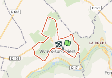

Length
7.3 km

Max alt
358 m

Uphill gradient
178 m
Km-Effort
9.6 km

Min alt
234 m

Downhill gradient
178 m
Boucle
Yes
Creation date :
2023-02-06 13:05:19.426
Updated on :
2023-02-06 15:25:52.688
2h19
Difficulty : Easy

FREE GPS app for hiking
 SityTrail
IGN / Geographical institutes
SityTrail Plus
The world is yours!
About
Trail Walking of 7.3 km to be discovered at Grand Est, Meurthe-et-Moselle, Viviers-sur-Chiers. This trail is proposed by veroberton.
Positioning
Country:
France
Region :
Grand Est
Department/Province :
Meurthe-et-Moselle
Municipality :
Viviers-sur-Chiers
Location:
Unknown
Start:(Dec)
Start:(UTM)
691051 ; 5483517 (31U) N.
Comments