


Boissieres

rando30129
User
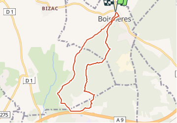

Length
8.2 km

Max alt
98 m

Uphill gradient
122 m
Km-Effort
9.8 km

Min alt
37 m

Downhill gradient
122 m
Boucle
Yes
Creation date :
2023-02-06 12:56:42.614
Updated on :
2023-07-09 08:30:10.399
2h13
Difficulty : Medium

FREE GPS app for hiking
 SityTrail
IGN / Geographical institutes
SityTrail Plus
The world is yours!
About
Trail Walking of 8.2 km to be discovered at Occitania, Gard, Boissières. This trail is proposed by rando30129.
Positioning
Country:
France
Region :
Occitania
Department/Province :
Gard
Municipality :
Boissières
Location:
Unknown
Start:(Dec)
Start:(UTM)
599322 ; 4847792 (31T) N.
Comments