


Pavant du 06/02/2023

VANDERPUTTENMi
User GUIDE
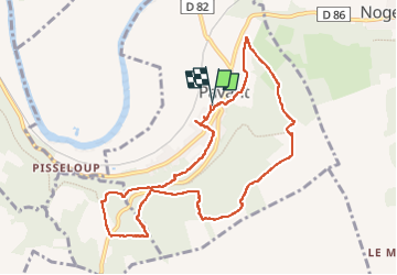

Length
9.6 km

Max alt
205 m

Uphill gradient
213 m
Km-Effort
12.4 km

Min alt
61 m

Downhill gradient
211 m
Boucle
Yes
Creation date :
2023-02-06 13:16:34.563
Updated on :
2023-02-06 18:15:25.969
2h15
Difficulty : Difficult

FREE GPS app for hiking
 SityTrail
IGN / Geographical institutes
SityTrail Plus
The world is yours!
About
Trail Walking of 9.6 km to be discovered at Hauts-de-France, Aisne, Pavant. This trail is proposed by VANDERPUTTENMi.
Photos

Positioning
Country:
France
Region :
Hauts-de-France
Department/Province :
Aisne
Municipality :
Pavant
Location:
Unknown
Start:(Dec)
Start:(UTM)
520949 ; 5422535 (31U) N.
Comments