


l' escalet cap lardier

vincente204
User
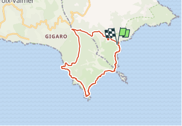

Length
14.4 km

Max alt
196 m

Uphill gradient
405 m
Km-Effort
19.8 km

Min alt
0 m

Downhill gradient
410 m
Boucle
Yes
Creation date :
2023-02-06 20:16:13.156
Updated on :
2023-02-06 20:17:10.182
4h29
Difficulty : Very difficult

FREE GPS app for hiking
 SityTrail
IGN / Geographical institutes
SityTrail Plus
The world is yours!
About
Trail Walking of 14.4 km to be discovered at Provence-Alpes-Côte d'Azur, Var, Ramatuelle. This trail is proposed by vincente204.
Description
facile
Positioning
Country:
France
Region :
Provence-Alpes-Côte d'Azur
Department/Province :
Var
Municipality :
Ramatuelle
Location:
Unknown
Start:(Dec)
Start:(UTM)
308294 ; 4784185 (32T) N.
Comments