


La Ronze-ini-télégraphe

ophness
User
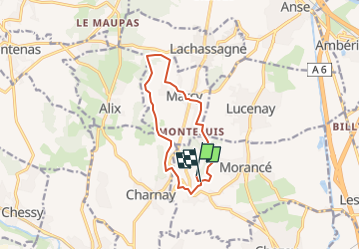

Length
10.6 km

Max alt
431 m

Uphill gradient
262 m
Km-Effort
14.1 km

Min alt
265 m

Downhill gradient
276 m
Boucle
No
Creation date :
2023-02-06 22:22:27.545
Updated on :
2023-02-06 22:28:11.113
1h51
Difficulty : Easy

FREE GPS app for hiking
 SityTrail
IGN / Geographical institutes
SityTrail Plus
The world is yours!
About
Trail Horseback riding of 10.6 km to be discovered at Auvergne-Rhône-Alpes, Rhône, Morancé. This trail is proposed by ophness.
Positioning
Country:
France
Region :
Auvergne-Rhône-Alpes
Department/Province :
Rhône
Municipality :
Morancé
Location:
Unknown
Start:(Dec)
Start:(UTM)
630542 ; 5083882 (31T) N.
Comments