


coutevroult RS

LaurentBernard
User
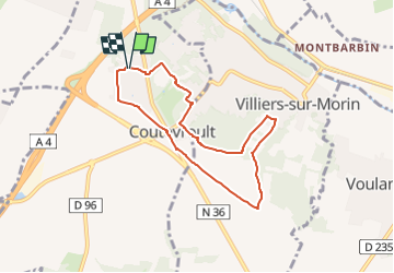

Length
6.7 km

Max alt
140 m

Uphill gradient
74 m
Km-Effort
7.7 km

Min alt
81 m

Downhill gradient
73 m
Boucle
Yes
Creation date :
2023-02-07 07:43:54.345
Updated on :
2023-02-07 07:44:38.83
1h44
Difficulty : Easy

FREE GPS app for hiking
 SityTrail
IGN / Geographical institutes
SityTrail Plus
The world is yours!
About
Trail On foot of 6.7 km to be discovered at Ile-de-France, Seine-et-Marne, Coutevroult. This trail is proposed by LaurentBernard.
Positioning
Country:
France
Region :
Ile-de-France
Department/Province :
Seine-et-Marne
Municipality :
Coutevroult
Location:
Unknown
Start:(Dec)
Start:(UTM)
489233 ; 5412248 (31U) N.
Comments