


Meung PR4

jcpinon
User
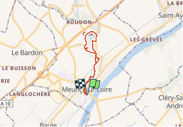

Length
9.7 km

Max alt
102 m

Uphill gradient
58 m
Km-Effort
10.5 km

Min alt
88 m

Downhill gradient
58 m
Boucle
Yes
Creation date :
2023-02-07 07:14:03.709
Updated on :
2023-02-07 10:17:00.424
2h16
Difficulty : Easy

FREE GPS app for hiking
 SityTrail
IGN / Geographical institutes
SityTrail Plus
The world is yours!
About
Trail Walking of 9.7 km to be discovered at Centre-Loire Valley, Loiret, Meung-sur-Loire. This trail is proposed by jcpinon.
Positioning
Country:
France
Region :
Centre-Loire Valley
Department/Province :
Loiret
Municipality :
Meung-sur-Loire
Location:
Unknown
Start:(Dec)
Start:(UTM)
402491 ; 5297572 (31T) N.
Comments