


20 km de Montmorency

pmauvieux
User
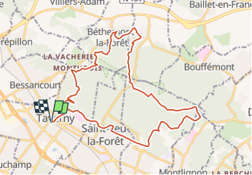

Length
20 km

Max alt
200 m

Uphill gradient
484 m
Km-Effort
27 km

Min alt
88 m

Downhill gradient
484 m
Boucle
Yes
Creation date :
2023-02-07 13:19:34.117
Updated on :
2023-02-07 13:23:39.631
6h30
Difficulty : Very difficult

FREE GPS app for hiking
 SityTrail
IGN / Geographical institutes
SityTrail Plus
The world is yours!
About
Trail Walking of 20 km to be discovered at Ile-de-France, Val-d'Oise, Taverny. This trail is proposed by pmauvieux.
Positioning
Country:
France
Region :
Ile-de-France
Department/Province :
Val-d'Oise
Municipality :
Taverny
Location:
Unknown
Start:(Dec)
Start:(UTM)
443099 ; 5430550 (31U) N.
Comments