


chapelle Sainte Blaise

PatriceCocuaud
User
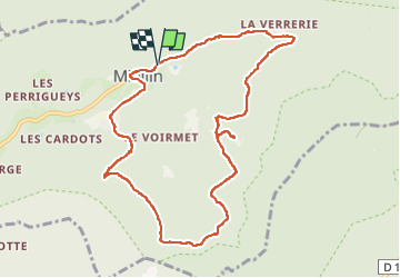

Length
10.4 km

Max alt
918 m

Uphill gradient
443 m
Km-Effort
16.4 km

Min alt
569 m

Downhill gradient
453 m
Boucle
Yes
Creation date :
2023-02-07 10:31:30.871
Updated on :
2023-02-07 13:55:18.56
3h22
Difficulty : Medium

FREE GPS app for hiking
 SityTrail
IGN / Geographical institutes
SityTrail Plus
The world is yours!
About
Trail Walking of 10.4 km to be discovered at Bourgogne-Franche-Comté, Haute-Saône, Servance-Miellin. This trail is proposed by PatriceCocuaud.
Positioning
Country:
France
Region :
Bourgogne-Franche-Comté
Department/Province :
Haute-Saône
Municipality :
Servance-Miellin
Location:
Miellin
Start:(Dec)
Start:(UTM)
330999 ; 5297842 (32T) N.
Comments