


Camping

Henri.Vekemans
User

Length
6 km

Max alt
224 m

Uphill gradient
52 m
Km-Effort
6.7 km

Min alt
212 m

Downhill gradient
50 m
Boucle
Yes
Creation date :
2023-02-07 14:40:40.596
Updated on :
2023-02-07 16:05:08.017
1h23
Difficulty : Medium

FREE GPS app for hiking
 SityTrail
IGN / Geographical institutes
SityTrail Plus
The world is yours!
About
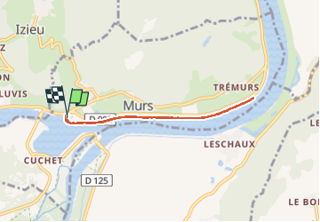
Trail Walking of 6 km to be discovered at Auvergne-Rhône-Alpes, Ain, Murs-et-Gélignieux. This trail is proposed by Henri.Vekemans.
Positioning
Country:
France
Region :
Auvergne-Rhône-Alpes
Department/Province :
Ain
Municipality :
Murs-et-Gélignieux
Location:
Unknown
Start:(Dec)
Start:(UTM)
706378 ; 5057410 (31T) N.
Comments