


La forêt des Lauriers

denissculier
User
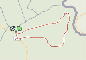

Length
7.7 km

Max alt
371 m

Uphill gradient
225 m
Km-Effort
10.7 km

Min alt
196 m

Downhill gradient
225 m
Boucle
Yes
Creation date :
2023-02-07 17:07:16.147
Updated on :
2023-02-08 13:14:01.027
2h24
Difficulty : Medium

FREE GPS app for hiking
 SityTrail
IGN / Geographical institutes
SityTrail Plus
The world is yours!
About
Trail Nordic walking of 7.7 km to be discovered at Grand Est, Ardennes, Hargnies. This trail is proposed by denissculier.
Description
Une randonnée agréable et de faible dénivelé permettant de s’immerger dans le calme et la quiétude de la forêt du plateau ardennais.
Positioning
Country:
France
Region :
Grand Est
Department/Province :
Ardennes
Municipality :
Hargnies
Location:
Unknown
Start:(Dec)
Start:(UTM)
627838 ; 5545436 (31U) N.
Comments