


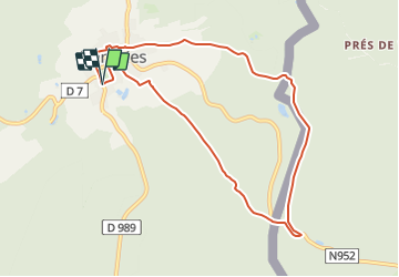
RESEAU ELFE La boucle de la frontière

denissculier
User


2h19
Difficulty : Medium

FREE GPS app for hiking
 SityTrail
IGN / Geographical institutes
SityTrail Plus
The world is yours!
About
Trail Nordic walking of 8.3 km to be discovered at Grand Est, Ardennes, Hargnies. This trail is proposed by denissculier.
Description
Découvrez au milieu de la forêt profonde de l’Ardenne, Hargnies et ses clairières, puis enjambez les eaux claires de la Hulle pour passer en Belgique dans ce secteur connu jadis comme lieu de contrebande du tabac et du café. Cette boucle du vaste réseau ELFE dispose de panneaux didactiques pour petits et grands.
Positioning
Comments