


RandoHuitrePP2023

FPortier
User

Length
4.8 km

Max alt
233 m

Uphill gradient
81 m
Km-Effort
5.9 km

Min alt
159 m

Downhill gradient
77 m
Boucle
Yes
Creation date :
2023-02-08 13:48:16.516
Updated on :
2023-02-08 15:23:18.272
1h34
Difficulty : Easy

FREE GPS app for hiking
 SityTrail
IGN / Geographical institutes
SityTrail Plus
The world is yours!
About
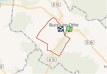
Trail Walking of 4.8 km to be discovered at Grand Est, Aube, Bucey-en-Othe. This trail is proposed by FPortier.
Description
Balade campagne Bucey
Positioning
Country:
France
Region :
Grand Est
Department/Province :
Aube
Municipality :
Bucey-en-Othe
Location:
Unknown
Start:(Dec)
Start:(UTM)
564191 ; 5345002 (31U) N.
Comments