


la chaudière-pennes le sec

ophness
User
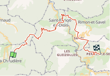

Length
18.7 km

Max alt
884 m

Uphill gradient
875 m
Km-Effort
31 km

Min alt
348 m

Downhill gradient
986 m
Boucle
No
Creation date :
2023-02-09 14:43:36.883
Updated on :
2023-02-09 14:44:00.135
4h02
Difficulty : Medium

FREE GPS app for hiking
 SityTrail
IGN / Geographical institutes
SityTrail Plus
The world is yours!
About
Trail Horseback riding of 18.7 km to be discovered at Auvergne-Rhône-Alpes, Drôme, La Chaudière. This trail is proposed by ophness.
Positioning
Country:
France
Region :
Auvergne-Rhône-Alpes
Department/Province :
Drôme
Municipality :
La Chaudière
Location:
Unknown
Start:(Dec)
Start:(UTM)
675725 ; 4944407 (31T) N.
Comments