


BASE Antheor

LEDUNC
User
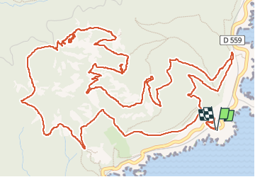

Length
12.1 km

Max alt
440 m

Uphill gradient
613 m
Km-Effort
20 km

Min alt
32 m

Downhill gradient
613 m
Boucle
Yes
Creation date :
2023-02-09 09:08:03.649
Updated on :
2023-02-10 15:59:08.965
3h40
Difficulty : Very difficult

FREE GPS app for hiking
 SityTrail
IGN / Geographical institutes
SityTrail Plus
The world is yours!
About
Trail Walking of 12.1 km to be discovered at Provence-Alpes-Côte d'Azur, Var, Saint-Raphaël. This trail is proposed by LEDUNC.
Description
Rando dans les pierriers, grottes, vues sur Cannes et iles de Lérins.
Bonnes chaussures.
Positioning
Country:
France
Region :
Provence-Alpes-Côte d'Azur
Department/Province :
Var
Municipality :
Saint-Raphaël
Location:
Unknown
Start:(Dec)
Start:(UTM)
331516 ; 4812814 (32T) N.
Comments