


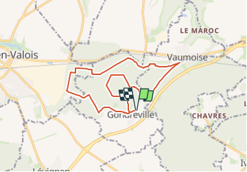
PN_Gondreville-NORD N2_15Km

GR77LP
User

Length
14.6 km

Max alt
162 m

Uphill gradient
183 m
Km-Effort
17.1 km

Min alt
107 m

Downhill gradient
182 m
Boucle
Yes
Creation date :
2023-02-09 15:03:44.835
Updated on :
2023-04-21 17:57:47.991
3h46
Difficulty : Difficult

FREE GPS app for hiking
 SityTrail
IGN / Geographical institutes
SityTrail Plus
The world is yours!
About
Trail Walking of 14.6 km to be discovered at Hauts-de-France, Oise, Gondreville. This trail is proposed by GR77LP.
Positioning
Country:
France
Region :
Hauts-de-France
Department/Province :
Oise
Municipality :
Gondreville
Location:
Unknown
Start:(Dec)
Start:(UTM)
496948 ; 5451654 (31U) N.
Comments