


Circuit du Mont Malgré Tout

denissculier
User
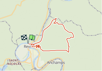

Length
14 km

Max alt
446 m

Uphill gradient
379 m
Km-Effort
19 km

Min alt
122 m

Downhill gradient
379 m
Boucle
Yes
Creation date :
2023-02-09 17:07:41.774
Updated on :
2024-02-03 15:39:44.515
4h17
Difficulty : Very difficult

FREE GPS app for hiking
 SityTrail
IGN / Geographical institutes
SityTrail Plus
The world is yours!
About
Trail Nordic walking of 14 km to be discovered at Grand Est, Ardennes, Revin. This trail is proposed by denissculier.
Description
Ce circuit, situé sur les monts entourants Revin, vous fera passer par de nombreux points de vue.
Positioning
Country:
France
Region :
Grand Est
Department/Province :
Ardennes
Municipality :
Revin
Location:
Unknown
Start:(Dec)
Start:(UTM)
617465 ; 5533696 (31U) N.
Comments