


Ta Ashe said

chripaci
User
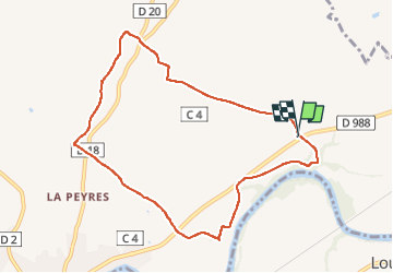

Length
9.3 km

Max alt
154 m

Uphill gradient
61 m
Km-Effort
10.1 km

Min alt
108 m

Downhill gradient
58 m
Boucle
Yes
Creation date :
2023-02-10 13:01:27.0
Updated on :
2023-02-10 15:04:30.856
2h02
Difficulty : Easy

FREE GPS app for hiking
 SityTrail
IGN / Geographical institutes
SityTrail Plus
The world is yours!
About
Trail Nordic walking of 9.3 km to be discovered at Occitania, Tarn, Rabastens. This trail is proposed by chripaci.
Description
Boucle facile
Positioning
Country:
France
Region :
Occitania
Department/Province :
Tarn
Municipality :
Rabastens
Location:
Unknown
Start:(Dec)
Start:(UTM)
400631 ; 4855134 (31T) N.
Comments