


Bassin Bures-Gif

pb07
User
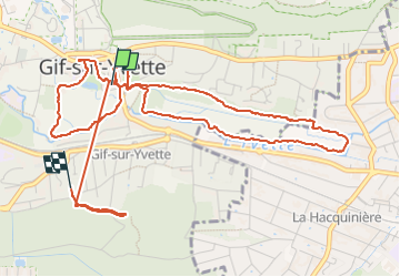

Length
6.4 km

Max alt
126 m

Uphill gradient
95 m
Km-Effort
7.6 km

Min alt
58 m

Downhill gradient
64 m
Boucle
No
Creation date :
2023-02-10 14:01:50.041
Updated on :
2023-02-10 16:05:18.57
1h54
Difficulty : Medium

FREE GPS app for hiking
 SityTrail
IGN / Geographical institutes
SityTrail Plus
The world is yours!
About
Trail Walking of 6.4 km to be discovered at Ile-de-France, Essonne, Gif-sur-Yvette. This trail is proposed by pb07.
Positioning
Country:
France
Region :
Ile-de-France
Department/Province :
Essonne
Municipality :
Gif-sur-Yvette
Location:
Unknown
Start:(Dec)
Start:(UTM)
436373 ; 5394569 (31U) N.
Comments