


Mn1102

pe78
User
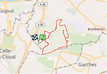

Length
8.7 km

Max alt
175 m

Uphill gradient
157 m
Km-Effort
10.8 km

Min alt
115 m

Downhill gradient
158 m
Boucle
Yes
Creation date :
2023-02-11 08:57:45.0
Updated on :
2023-02-11 10:43:04.269
1h44
Difficulty : Unknown

FREE GPS app for hiking
 SityTrail
IGN / Geographical institutes
SityTrail Plus
The world is yours!
About
Trail Nordic walking of 8.7 km to be discovered at Ile-de-France, Hauts-de-Seine, Rueil-Malmaison. This trail is proposed by pe78.
Positioning
Country:
France
Region :
Ile-de-France
Department/Province :
Hauts-de-Seine
Municipality :
Rueil-Malmaison
Location:
Unknown
Start:(Dec)
Start:(UTM)
438174 ; 5411305 (31U) N.
Comments