


les ramier es la puce

ymobernard
User
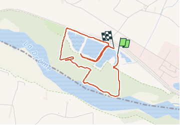

Length
4.4 km

Max alt
166 m

Uphill gradient
31 m
Km-Effort
4.8 km

Min alt
152 m

Downhill gradient
28 m
Boucle
Yes
Creation date :
2023-02-11 14:37:30.781
Updated on :
2023-02-11 16:21:28.753
1h20
Difficulty : Very easy

FREE GPS app for hiking
 SityTrail
IGN / Geographical institutes
SityTrail Plus
The world is yours!
About
Trail Walking of 4.4 km to be discovered at Auvergne-Rhône-Alpes, Drôme, Eurre. This trail is proposed by ymobernard.
Positioning
Country:
France
Region :
Auvergne-Rhône-Alpes
Department/Province :
Drôme
Municipality :
Eurre
Location:
Unknown
Start:(Dec)
Start:(UTM)
655832 ; 4955782 (31T) N.
Comments