


ghuio

Clo0413
User
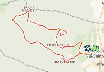

Length
14 km

Max alt
1202 m

Uphill gradient
642 m
Km-Effort
23 km

Min alt
614 m

Downhill gradient
642 m
Boucle
Yes
Creation date :
2023-02-12 08:00:03.44
Updated on :
2023-02-12 14:36:02.767
3h57
Difficulty : Very difficult

FREE GPS app for hiking
 SityTrail
IGN / Geographical institutes
SityTrail Plus
The world is yours!
About
Trail Walking of 14 km to be discovered at Provence-Alpes-Côte d'Azur, Alpes-de-Haute-Provence, Châteauneuf-Val-Saint-Donat. This trail is proposed by Clo0413.
Positioning
Country:
France
Region :
Provence-Alpes-Côte d'Azur
Department/Province :
Alpes-de-Haute-Provence
Municipality :
Châteauneuf-Val-Saint-Donat
Location:
Unknown
Start:(Dec)
Start:(UTM)
735614 ; 4886369 (31T) N.
Comments