


arrigas

Bwattier
User
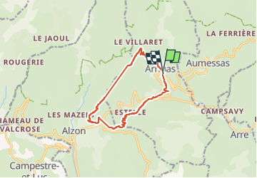

Length
11.9 km

Max alt
865 m

Uphill gradient
586 m
Km-Effort
19.7 km

Min alt
408 m

Downhill gradient
584 m
Boucle
Yes
Creation date :
2023-02-12 09:17:29.313
Updated on :
2023-02-12 15:01:35.147
3h48
Difficulty : Very difficult

FREE GPS app for hiking
 SityTrail
IGN / Geographical institutes
SityTrail Plus
The world is yours!
About
Trail Walking of 11.9 km to be discovered at Occitania, Gard, Arrigas. This trail is proposed by Bwattier.
Positioning
Country:
France
Region :
Occitania
Department/Province :
Gard
Municipality :
Arrigas
Location:
Unknown
Start:(Dec)
Start:(UTM)
538649 ; 4870641 (31T) N.
Comments