


Sarrat de Sacroues depuis Poubeau

lhomme.ph
User GUIDE
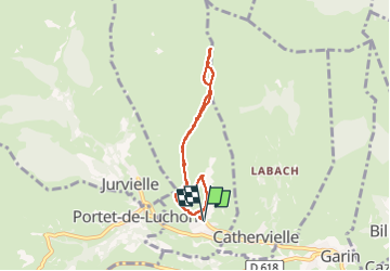

Length
6.4 km

Max alt
1885 m

Uphill gradient
631 m
Km-Effort
14.8 km

Min alt
1244 m

Downhill gradient
632 m
Boucle
Yes
Creation date :
2023-02-12 10:01:27.707
Updated on :
2023-02-12 15:12:44.115
5h10
Difficulty : Medium

FREE GPS app for hiking
 SityTrail
IGN / Geographical institutes
SityTrail Plus
The world is yours!
About
Trail Walking of 6.4 km to be discovered at Occitania, Haute-Garonne, Poubeau. This trail is proposed by lhomme.ph.
Photos

Positioning
Country:
France
Region :
Occitania
Department/Province :
Haute-Garonne
Municipality :
Poubeau
Location:
Unknown
Start:(Dec)
Start:(UTM)
295408 ; 4743034 (31T) N.
Comments