


vlt 1026F - radar de Giens court

jmheydorff
User
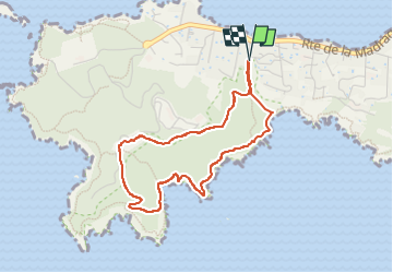

Length
4 km

Max alt
98 m

Uphill gradient
144 m
Km-Effort
5.9 km

Min alt
9 m

Downhill gradient
144 m
Boucle
Yes
Creation date :
2023-02-12 13:33:36.724
Updated on :
2023-02-13 08:24:03.265
1h28
Difficulty : Easy

FREE GPS app for hiking
 SityTrail
IGN / Geographical institutes
SityTrail Plus
The world is yours!
About
Trail Walking of 4 km to be discovered at Provence-Alpes-Côte d'Azur, Var, Hyères. This trail is proposed by jmheydorff.
Positioning
Country:
France
Region :
Provence-Alpes-Côte d'Azur
Department/Province :
Var
Municipality :
Hyères
Location:
Unknown
Start:(Dec)
Start:(UTM)
264603 ; 4769122 (32T) N.
Comments