


Perena de la ribera

taguette
User
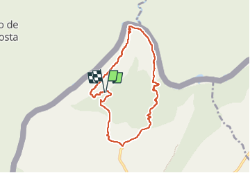

Length
8.2 km

Max alt
692 m

Uphill gradient
427 m
Km-Effort
13.9 km

Min alt
334 m

Downhill gradient
428 m
Boucle
Yes
Creation date :
2023-02-13 08:49:36.126
Updated on :
2023-02-13 11:37:31.653
2h45
Difficulty : Medium

FREE GPS app for hiking
 SityTrail
IGN / Geographical institutes
SityTrail Plus
The world is yours!
About
Trail Walking of 8.2 km to be discovered at Castile and León, Unknown, Pereña de la Ribera. This trail is proposed by taguette.
Positioning
Country:
Spain
Region :
Castile and León
Department/Province :
Unknown
Municipality :
Pereña de la Ribera
Location:
Unknown
Start:(Dec)
Start:(UTM)
707135 ; 4570897 (29T) N.
Comments