


exp_12 Feb 2023 at 18-21-43.gpx

Tourisme Equestre Alsace
Promouvoir le Tourisme Equestre en Alsace GUIDE+
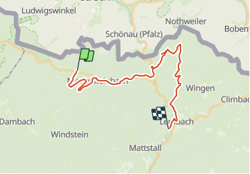

Length
23 km

Max alt
385 m

Uphill gradient
458 m
Km-Effort
30 km

Min alt
190 m

Downhill gradient
495 m
Boucle
No
Creation date :
2023-02-13 18:29:39.504
Updated on :
2023-07-10 14:28:10.049
0m
Difficulty : Medium

FREE GPS app for hiking
 SityTrail
IGN / Geographical institutes
SityTrail Plus
The world is yours!
About
Trail Coupling of 23 km to be discovered at Grand Est, Bas-Rhin, Obersteinbach. This trail is proposed by Tourisme Equestre Alsace.
Photos


Positioning
Country:
France
Region :
Grand Est
Department/Province :
Bas-Rhin
Municipality :
Obersteinbach
Location:
Unknown
Start:(Dec)
Start:(UTM)
404368 ; 5432343 (32U) N.
Comments